


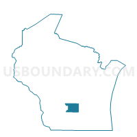
Pardeeville - V 2 Voting District, Columbia County, Wisconsin
About
Outline

Summary
| Unique Area Identifier | 692810 |
| Name | Pardeeville - V 2 Voting District |
| County | Columbia County |
| State | Wisconsin |
| Area (square miles) | 0.69 |
| Land Area (square miles) | 0.67 |
| Water Area (square miles) | 0.01 |
| % of Land Area | 97.99 |
| % of Water Area | 2.01 |
| Latitude of the Internal Point | 43.53253120 |
| Longtitude of the Internal Point | -89.29317940 |
Maps


Graphs
Select a template below for downloading or customizing gragh for Pardeeville - V 2 Voting District, Columbia County, Wisconsin


Neighbors
Neighoring Voting District (by Name) Neighboring Voting District on the Map
- Pardeeville - V 1 Voting District, Columbia County, WI
- Pardeeville - V 3 Voting District, Columbia County, WI
- WYOCENA - T 2 Voting District, Columbia County, WI
- WYOCENA - T 3 Voting District, Columbia County, WI